


Saint-Ouen-les-Vignes - Pocé-sur-Cisse 460 - 23.9km 460m 5h40 - 2022 05 29

Orcal37
Gebruiker GUIDE
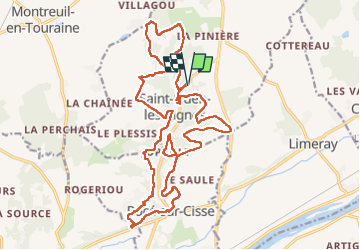

Lengte
24 km

Max. hoogte
114 m

Positief hoogteverschil
462 m
Km-Effort
30 km

Min. hoogte
58 m

Negatief hoogteverschil
461 m
Boucle
Ja
Datum van aanmaak :
2022-05-29 09:34:04.756
Laatste wijziging :
2022-05-29 18:04:39.243
5h40
Moeilijkheid : Medium

Gratisgps-wandelapplicatie
 SityTrail
IGN / Geografische instituten
SityTrail Plus
De wereld gaat voor u open
Over ons
Tocht Stappen van 24 km beschikbaar op Centre-Val de Loire, Indre-et-Loire, Saint-Ouen-les-Vignes. Deze tocht wordt voorgesteld door Orcal37.
Beschrijving
Saint-Ouen-les-Vignes - Pocé-sur-Cisse 460 - 23.9km 460m 5h40 - 2022 05 29
Foto's


Plaatsbepaling
Land:
France
Regio :
Centre-Val de Loire
Departement/Provincie :
Indre-et-Loire
Gemeente :
Saint-Ouen-les-Vignes
Locatie:
Unknown
Vertrek:(Dec)
Vertrek:(UTM)
349099 ; 5259604 (31T) N.
Opmerkingen