


PHIL-Avize-41kms-Entre_forêts_et_coteaux_-_Circuit_cyclotouristique

jeanphi.hennebert
Gebruiker
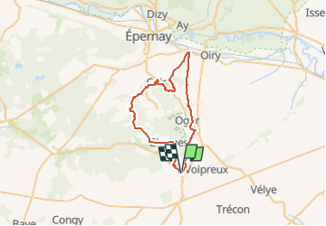

Lengte
42 km

Max. hoogte
242 m

Positief hoogteverschil
612 m
Km-Effort
50 km

Min. hoogte
79 m

Negatief hoogteverschil
611 m
Boucle
Ja
Datum van aanmaak :
2022-05-30 09:12:48.978
Laatste wijziging :
2022-07-04 08:37:27.118
3h26
Moeilijkheid : Zeer moeilijk
--
Moeilijkheid : Zeer moeilijk

Gratisgps-wandelapplicatie
 SityTrail
IGN / Geografische instituten
SityTrail Plus
De wereld gaat voor u open
Over ons
Tocht Mountainbike van 42 km beschikbaar op Grand Est, Marne, Blancs-Coteaux. Deze tocht wordt voorgesteld door jeanphi.hennebert.
Plaatsbepaling
Land:
France
Regio :
Grand Est
Departement/Provincie :
Marne
Gemeente :
Blancs-Coteaux
Locatie:
Unknown
Vertrek:(Dec)
Vertrek:(UTM)
573533 ; 5417439 (31U) N.
Opmerkingen