


Trace Garlin M2 Guy

mitch1952
Gebruiker
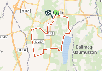

Lengte
8,3 km

Max. hoogte
217 m

Positief hoogteverschil
122 m
Km-Effort
9,9 km

Min. hoogte
139 m

Negatief hoogteverschil
123 m
Boucle
Ja
Datum van aanmaak :
2022-06-01 11:48:18.0
Laatste wijziging :
2022-06-01 14:26:30.105
2h04
Moeilijkheid : Onbekend

Gratisgps-wandelapplicatie
 SityTrail
IGN / Geografische instituten
SityTrail Plus
De wereld gaat voor u open
Over ons
Tocht Stappen van 8,3 km beschikbaar op Nieuw-Aquitanië, Pyrénées-Atlantiques, Garlin. Deze tocht wordt voorgesteld door mitch1952.
Plaatsbepaling
Land:
France
Regio :
Nieuw-Aquitanië
Departement/Provincie :
Pyrénées-Atlantiques
Gemeente :
Garlin
Locatie:
Unknown
Vertrek:(Dec)
Vertrek:(UTM)
720162 ; 4826480 (30T) N.
Opmerkingen