


Epernon Villiers le Morhier houx

topophil
Gebruiker
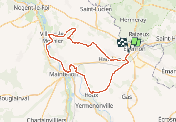

Lengte
31 km

Max. hoogte
162 m

Positief hoogteverschil
231 m
Km-Effort
34 km

Min. hoogte
96 m

Negatief hoogteverschil
232 m
Boucle
Ja
Datum van aanmaak :
2022-06-02 15:57:42.67
Laatste wijziging :
2022-06-02 18:16:05.42
2h18
Moeilijkheid : Moeilijk

Gratisgps-wandelapplicatie
 SityTrail
IGN / Geografische instituten
SityTrail Plus
De wereld gaat voor u open
Over ons
Tocht Mountainbike van 31 km beschikbaar op Centre-Val de Loire, Eure-et-Loir, Épernon. Deze tocht wordt voorgesteld door topophil.
Plaatsbepaling
Land:
France
Regio :
Centre-Val de Loire
Departement/Provincie :
Eure-et-Loir
Gemeente :
Épernon
Locatie:
Unknown
Vertrek:(Dec)
Vertrek:(UTM)
401972 ; 5384526 (31U) N.
Opmerkingen