


2022 06 Ardeche j4 /6

ericf64
Gebruiker

Lengte
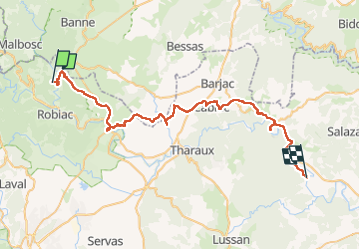
55 km

Max. hoogte
349 m

Positief hoogteverschil
786 m
Km-Effort
66 km

Min. hoogte
74 m

Negatief hoogteverschil
885 m
Boucle
Neen
Datum van aanmaak :
2022-06-10 06:53:40.246
Laatste wijziging :
2022-06-13 13:09:25.831
8h41
Moeilijkheid : Medium

Gratisgps-wandelapplicatie
 SityTrail
IGN / Geografische instituten
SityTrail Plus
De wereld gaat voor u open
Over ons
Tocht Fietstoerisme van 55 km beschikbaar op Occitanië, Gard, Gagnières. Deze tocht wordt voorgesteld door ericf64.
Beschrijving
Gagnieres à Goudargues
Plaatsbepaling
Land:
France
Regio :
Occitanië
Departement/Provincie :
Gard
Gemeente :
Gagnières
Locatie:
Unknown
Vertrek:(Dec)
Vertrek:(UTM)
589354 ; 4906622 (31T) N.
Opmerkingen