


lure

PatriceCocuaud
Gebruiker
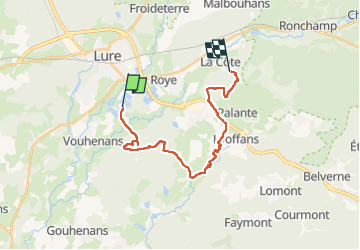

Lengte
18,6 km

Max. hoogte
346 m

Positief hoogteverschil
258 m
Km-Effort
22 km

Min. hoogte
284 m

Negatief hoogteverschil
209 m
Boucle
Neen
Datum van aanmaak :
2022-06-12 07:14:23.023
Laatste wijziging :
2022-06-12 08:58:57.8
1h44
Moeilijkheid : Medium

Gratisgps-wandelapplicatie
 SityTrail
IGN / Geografische instituten
SityTrail Plus
De wereld gaat voor u open
Over ons
Tocht Mountainbike van 18,6 km beschikbaar op Bourgondië-Franche-Comté, Haute-Saône, Lure. Deze tocht wordt voorgesteld door PatriceCocuaud.
Plaatsbepaling
Land:
France
Regio :
Bourgondië-Franche-Comté
Departement/Provincie :
Haute-Saône
Gemeente :
Lure
Locatie:
Unknown
Vertrek:(Dec)
Vertrek:(UTM)
312703 ; 5281847 (32T) N.
Opmerkingen