


Pyrée

jcm17
Gebruiker

Lengte
34 km

Max. hoogte
251 m

Positief hoogteverschil
399 m
Km-Effort
40 km

Min. hoogte
-4 m

Negatief hoogteverschil
552 m
Boucle
Neen
Datum van aanmaak :
2022-06-05 14:28:17.833
Laatste wijziging :
2022-06-12 18:15:29.491
27m
Moeilijkheid : Heel gemakkelijk

Gratisgps-wandelapplicatie
 SityTrail
IGN / Geografische instituten
SityTrail Plus
De wereld gaat voor u open
Over ons
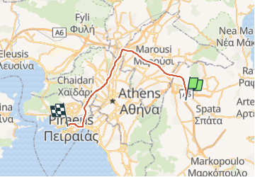
Tocht Auto van 34 km beschikbaar op Attica, Περιφερειακή Ενότητα Ανατολικής Αττικής. Deze tocht wordt voorgesteld door jcm17.
Plaatsbepaling
Land:
Greece
Regio :
Attica
Departement/Provincie :
Περιφερειακή Ενότητα Ανατολικής Αττικής
Gemeente :
Unknown
Locatie:
Unknown
Vertrek:(Dec)
Vertrek:(UTM)
752087 ; 4208058 (34S) N.
Opmerkingen