


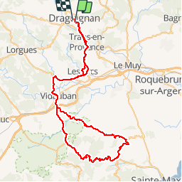
Plan de la tour-Col de Vignon.

Sugg
Gebruiker

Lengte
87 km

Max. hoogte
366 m

Positief hoogteverschil
1211 m
Km-Effort
103 km

Min. hoogte
39 m

Negatief hoogteverschil
1217 m
Boucle
Neen
Datum van aanmaak :
2019-03-22 17:00:06.764
Laatste wijziging :
2019-03-22 17:00:06.853
4h40
Moeilijkheid : Medium

Gratisgps-wandelapplicatie
 SityTrail
IGN / Geografische instituten
SityTrail Plus
De wereld gaat voor u open
Over ons
Tocht Fiets van 87 km beschikbaar op Provence-Alpes-Côte d'Azur, Var, Draguignan. Deze tocht wordt voorgesteld door Sugg.
Beschrijving
Sortie Vélo Cyclo de Restons en forme le 24 juillet 2014.( la durée, c'est avec les pauses, l'appli ne décompte pas les arrêts ).
Plaatsbepaling
Land:
France
Regio :
Provence-Alpes-Côte d'Azur
Departement/Provincie :
Var
Gemeente :
Draguignan
Locatie:
Unknown
Vertrek:(Dec)
Vertrek:(UTM)
295125 ; 4822986 (32T) N.
Opmerkingen