


Rando 2 Vallées 2023 Pédestre (7.9Kms Dén P 65m)

alain62rando
Gebruiker
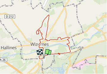

Lengte
7,9 km

Max. hoogte
53 m

Positief hoogteverschil
65 m
Km-Effort
8,7 km

Min. hoogte
18 m

Negatief hoogteverschil
65 m
Boucle
Ja
Datum van aanmaak :
2022-06-27 09:21:09.942
Laatste wijziging :
2023-05-12 05:06:58.765
1h59
Moeilijkheid : Gemakkelijk

Gratisgps-wandelapplicatie
 SityTrail
IGN / Geografische instituten
SityTrail Plus
De wereld gaat voor u open
Over ons
Tocht Stappen van 7,9 km beschikbaar op Hauts-de-France, Pas-de-Calais, Wizernes. Deze tocht wordt voorgesteld door alain62rando.
Plaatsbepaling
Land:
France
Regio :
Hauts-de-France
Departement/Provincie :
Pas-de-Calais
Gemeente :
Wizernes
Locatie:
Unknown
Vertrek:(Dec)
Vertrek:(UTM)
445714 ; 5617261 (31U) N.
Opmerkingen