


Cures attelage

xst
Gebruiker
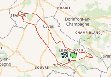

Lengte
18,5 km

Max. hoogte
169 m

Positief hoogteverschil
223 m
Km-Effort
21 km

Min. hoogte
99 m

Negatief hoogteverschil
224 m
Boucle
Ja
Datum van aanmaak :
2022-06-29 07:14:12.08
Laatste wijziging :
2022-06-29 10:03:48.564
2h35
Moeilijkheid : Heel gemakkelijk

Gratisgps-wandelapplicatie
 SityTrail
IGN / Geografische instituten
SityTrail Plus
De wereld gaat voor u open
Over ons
Tocht Huifkarwandeling van 18,5 km beschikbaar op Pays de la Loire, Sarthe, Cures. Deze tocht wordt voorgesteld door xst.
Plaatsbepaling
Land:
France
Regio :
Pays de la Loire
Departement/Provincie :
Sarthe
Gemeente :
Cures
Locatie:
Unknown
Vertrek:(Dec)
Vertrek:(UTM)
277904 ; 5328769 (31U) N.
Opmerkingen