


GR 10

georghinio
Gebruiker


8h00
Moeilijkheid : Zeer moeilijk

Gratisgps-wandelapplicatie
 SityTrail
IGN / Geografische instituten
SityTrail Plus
De wereld gaat voor u open
Over ons
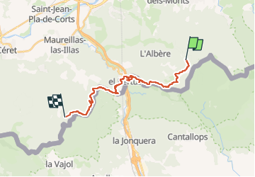
Tocht Stappen van 23 km beschikbaar op Occitanië, Pyrénées-Orientales, L'Albère. Deze tocht wordt voorgesteld door georghinio.
Beschrijving
Appli pas activée mais départ de la fontaine de la Tanyarède jusqu'au Mas Nou(source) randonnée longue et lassante par de nombreuses pistes forestières et traversée nulle du Perthus.
Rajoutez 1h20 environ
Plaatsbepaling
Opmerkingen