


Rando Pas de Roland

Fab-Oz
Gebruiker

Lengte
7,1 km

Max. hoogte
350 m

Positief hoogteverschil
324 m
Km-Effort
11,5 km

Min. hoogte
40 m

Negatief hoogteverschil
322 m
Boucle
Ja
Datum van aanmaak :
2022-07-06 13:38:58.105
Laatste wijziging :
2022-07-06 15:14:56.328
1h34
Moeilijkheid : Gemakkelijk

Gratisgps-wandelapplicatie
 SityTrail
IGN / Geografische instituten
SityTrail Plus
De wereld gaat voor u open
Over ons
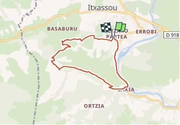
Tocht Stappen van 7,1 km beschikbaar op Nieuw-Aquitanië, Pyrénées-Atlantiques, Itxassou. Deze tocht wordt voorgesteld door Fab-Oz.
Beschrijving
Balade sympa au départ du Itxassou
Passage plat jusqu'au Pas de Roland
Montée assez facile jusqu'à Atharri (Legarreko Lepoa) puis retour en descente douce jusqu'au parking
Plaatsbepaling
Land:
France
Regio :
Nieuw-Aquitanië
Departement/Provincie :
Pyrénées-Atlantiques
Gemeente :
Itxassou
Locatie:
Unknown
Vertrek:(Dec)
Vertrek:(UTM)
629299 ; 4798218 (30T) N.
Opmerkingen