


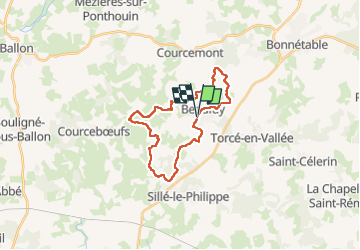
beaufay attelage

xst
Gebruiker

Lengte
22 km

Max. hoogte
150 m

Positief hoogteverschil
248 m
Km-Effort
26 km

Min. hoogte
64 m

Negatief hoogteverschil
248 m
Boucle
Ja
Datum van aanmaak :
2022-07-09 11:28:03.177
Laatste wijziging :
2022-07-09 14:45:21.706
2h43
Moeilijkheid : Gemakkelijk

Gratisgps-wandelapplicatie
 SityTrail
IGN / Geografische instituten
SityTrail Plus
De wereld gaat voor u open
Over ons
Tocht Huifkarwandeling van 22 km beschikbaar op Pays de la Loire, Sarthe, Beaufay. Deze tocht wordt voorgesteld door xst.
Plaatsbepaling
Land:
France
Regio :
Pays de la Loire
Departement/Provincie :
Sarthe
Gemeente :
Beaufay
Locatie:
Unknown
Vertrek:(Dec)
Vertrek:(UTM)
303497 ; 5335614 (31U) N.
Opmerkingen