


source bleue

mousetik
Gebruiker
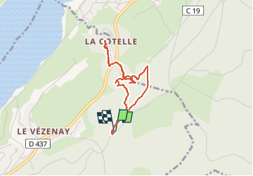

Lengte
3,6 km

Max. hoogte
1005 m

Positief hoogteverschil
164 m
Km-Effort
5,8 km

Min. hoogte
870 m

Negatief hoogteverschil
164 m
Boucle
Ja
Datum van aanmaak :
2022-07-13 08:53:02.295
Laatste wijziging :
2022-07-13 10:21:53.386
1h27
Moeilijkheid : Zeer moeilijk
Gratisgps-wandelapplicatie
 SityTrail
IGN / Geografische instituten
SityTrail Plus
De wereld gaat voor u open
Over ons
Tocht Stappen van 3,6 km beschikbaar op Bourgondië-Franche-Comté, Doubs, Malbuisson. Deze tocht wordt voorgesteld door mousetik.
Beschrijving
aller par le haut et back to the wild (non recommandé)
Plaatsbepaling
Land:
France
Regio :
Bourgondië-Franche-Comté
Departement/Provincie :
Doubs
Gemeente :
Malbuisson
Locatie:
Unknown
Vertrek:(Dec)
Vertrek:(UTM)
295665 ; 5186967 (32T) N.
Opmerkingen