Tocht Paard La Chapelle-en-Vercors - 20140907 Rando CVA Vercors Theorique - Photo

20140907 Rando CVA Vercors Theorique

 holtzv
holtzv

Gebruiker GUIDE

© OpenStreetMap contributors
Lengte
Lengte
22 km
Max. hoogte
Max. hoogte
1317 m
Positief hoogteverschil
786 m
Km-Effort
Km-Effort  
32 km
Min. hoogte
Min. hoogte
840 m
Negatief hoogteverschil
486 m
Boucle
Boucle
Neen
Datum van aanmaak :
2014-12-10 00:00:00.0
Laatste wijziging :
2014-12-10 00:00:00.0

(0 Bericht)

Paard
Paard
4h06
Moeilijkheid : Onbekend

Scan deze QR-code om de tocht te openen in de SityTrail-applicatie

Gratisgps-wandelapplicatie

Logo SityTrail SityTrail

IGN / Geografische instituten

SityTrail uit de App Store downloaden SityTrail uit Google Play downloaden

Logo SityTrail SityTrail Plus

De wereld gaat voor u open

SityTrail uit de App Store downloaden SityTrail uit Google Play downloaden SityTrail op Huawei AppGallery downloaden

Over ons

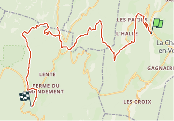
Tocht Paard van 22 km beschikbaar op Auvergne-Rhône-Alpes, Drôme, La Chapelle-en-Vercors. Deze tocht wordt voorgesteld door holtzv.

Hoogteprofiel

POI's

POI La Chapelle-en-Vercors - Gite Les Drevets - Photo
holtzv
LA CHAPELLE-EN-VERCORS 
POI Bouvante - Picnic - Photo
holtzv
BOUVANTE 
POI Saint-Jean-en-Royans - Point de vue - Photo
holtzv
SAINT-JEAN-EN-ROYANS 
POI Bouvante - Point de Vue - Photo
holtzv
BOUVANTE 
POI Bouvante - Gite Ferme de Lente - Photo
holtzv

Plaatsbepaling

Land:
France
Regio :
Auvergne-Rhône-Alpes
Departement/Provincie :
Drôme
Gemeente :
La Chapelle-en-Vercors
Locatie:
Unknown
Vertrek:(Dec)
Vertrek:(UTM)
689222 ; 4982914 (31T) N.


Sluiten
Mijn abonnementen