


Activity

Sarah92130
Gebruiker

Lengte
33 km

Max. hoogte
20 m

Positief hoogteverschil
153 m
Km-Effort
35 km

Min. hoogte
-1 m

Negatief hoogteverschil
149 m
Boucle
Neen
Datum van aanmaak :
2022-07-23 13:29:35.389
Laatste wijziging :
2022-07-23 13:31:37.467
0m
Moeilijkheid : Heel gemakkelijk

Gratisgps-wandelapplicatie
 SityTrail
IGN / Geografische instituten
SityTrail Plus
De wereld gaat voor u open
Over ons
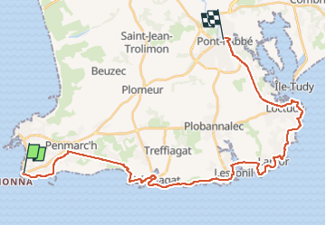
Tocht Fietstoerisme van 33 km beschikbaar op Bretagne, Finistère, Penmarc'h. Deze tocht wordt voorgesteld door Sarah92130.
Plaatsbepaling
Land:
France
Regio :
Bretagne
Departement/Provincie :
Finistère
Gemeente :
Penmarc'h
Locatie:
Unknown
Vertrek:(Dec)
Vertrek:(UTM)
397130 ; 5294814 (30T) N.
Opmerkingen