


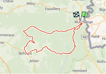
20200906 MARTELANGE - LE RANCH

BVB
Gebruiker

Lengte
38 km

Max. hoogte
518 m

Positief hoogteverschil
722 m
Km-Effort
48 km

Min. hoogte
362 m

Negatief hoogteverschil
723 m
Boucle
Ja
Datum van aanmaak :
2020-09-06 11:33:14.167
Laatste wijziging :
2022-07-24 19:38:31.698
3h31
Moeilijkheid : Gemakkelijk

Gratisgps-wandelapplicatie
 SityTrail
IGN / Geografische instituten
SityTrail Plus
De wereld gaat voor u open
Over ons
Tocht Mountainbike van 38 km beschikbaar op Wallonië, Luxemburg, Martelange. Deze tocht wordt voorgesteld door BVB.
Beschrijving
Belle randonnée dans la forêt d'ANLIER.
Des racines au début puis de la route pour finir.
Plaatsbepaling
Land:
Belgium
Regio :
Wallonië
Departement/Provincie :
Luxemburg
Gemeente :
Martelange
Locatie:
Martelange
Vertrek:(Dec)
Vertrek:(UTM)
696297 ; 5523566 (31U) N.
Opmerkingen