Tocht Stappen Arces - 17,Port Maran - Meschers  6km800 - Photo

17,Port Maran - Meschers 6km800

 Jos17
Jos17

Gebruiker

© OpenStreetMap contributors
Lengte
Lengte
6,8 km
Max. hoogte
Max. hoogte
18 m
Positief hoogteverschil
32 m
Km-Effort
Km-Effort  
7,3 km
Min. hoogte
Min. hoogte
0 m
Negatief hoogteverschil
33 m
Boucle
Boucle
Ja
Datum van aanmaak :
2022-07-27 06:50:10.077
Laatste wijziging :
2022-07-27 14:30:49.526

(0 Bericht)

Stappen
Stappen
2h05
Moeilijkheid : Gemakkelijk

Scan deze QR-code om de tocht te openen in de SityTrail-applicatie

Gratisgps-wandelapplicatie

Logo SityTrail SityTrail

IGN / Geografische instituten

SityTrail uit de App Store downloaden SityTrail uit Google Play downloaden

Logo SityTrail SityTrail World

De wereld gaat voor u open

SityTrail uit de App Store downloaden SityTrail uit Google Play downloaden SityTrail op Huawei AppGallery downloaden

Over ons

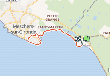
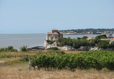
Tocht Stappen van 6,8 km beschikbaar op Nieuw-Aquitanië, Charente-Maritime, Arces. Deze tocht wordt voorgesteld door Jos17.

Beschrijving

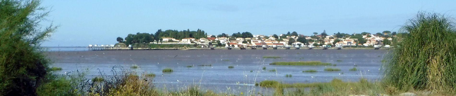
le long des marais jusqu'à Meschers et vues sur la corniche

Hoogteprofiel

Foto's

Plaatsbepaling

Land:
France
Regio :
Nieuw-Aquitanië
Departement/Provincie :
Charente-Maritime
Gemeente :
Arces
Locatie:
Unknown
Vertrek:(UTM)
662302 ; 5046335 (30T) N.

Wandeltochten in de omgeving

Tocht Te voet Saint-Georges-de-Didonne - 17 StGeorges -Chenaumoine - Photo
Te voet
Jos17

Te voet

Gemakkelijk
(2)
Saint-Georges-de-Didonne, Nieuw-Aquitanië, Charente-Maritime, France
6,6 km | 7,4 km-effort
1h 41min
Ja
Tocht Stappen Barzan - Barzan plage- Le Fâ - Le caillaud - Photo
Stappen
Gef50

Stappen

Medium
Barzan, Nieuw-Aquitanië, Charente-Maritime, France
9,4 km | 10,4 km-effort
3h 55min
Ja
Tocht Te voet Arces - Arces 17   -9km2 - Photo
Te voet
Jos17

Te voet

Gemakkelijk
Arces, Nieuw-Aquitanië, Charente-Maritime, France
7,3 km | 8,6 km-effort
1h 56min
Ja
Tocht Te voet Arces - Arces - Bardecille  17  (8km9) - Photo
Te voet
Jos17

Te voet

Gemakkelijk
Arces, Nieuw-Aquitanië, Charente-Maritime, France
8,9 km | 10,3 km-effort
Onbekend
Ja
Tocht Te voet Talmont-sur-Gironde - Talmont-Barzan 17   -8km6 - Photo
Te voet
Jos17

Te voet

Heel gemakkelijk
Talmont-sur-Gironde, Nieuw-Aquitanië, Charente-Maritime, France
8,6 km | 9,5 km-effort
2h 0min
Ja
Tocht Mountainbike Meschers-sur-Gironde - Espace VTT FFC Pays Royannais - Circuit n°01 - Photo
Mountainbike
tracegps

Mountainbike

Gemakkelijk
(1)
Meschers-sur-Gironde, Nieuw-Aquitanië, Charente-Maritime, France
16,7 km | 18,6 km-effort
1h 30min
Ja
Tocht Stappen Meschers-sur-Gironde - 17 Meschers  6km 5 - Photo
Stappen
Jos17

Stappen

Medium
Meschers-sur-Gironde, Nieuw-Aquitanië, Charente-Maritime, France
6,5 km | 7,4 km-effort
1h 41min
Ja
Tocht Wegfiets Barzan - Barzan plage vers Mécher sur Gironde et Talmon - Photo
Wegfiets
Reichling

Wegfiets

Heel gemakkelijk
Barzan, Nieuw-Aquitanië, Charente-Maritime, France
21 km | 23 km-effort
2h 58min
Ja
Tocht Stappen Saint-Georges-de-Didonne - forêt de suzac - Photo
Stappen
mattr91

Stappen

Gemakkelijk
Saint-Georges-de-Didonne, Nieuw-Aquitanië, Charente-Maritime, France
8,7 km | 10 km-effort
1h 53min
Ja


Sluiten
Mijn abonnementen