


Aubazines : Canal des Moines TC

mitch1952
Gebruiker
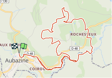

Lengte
8,8 km

Max. hoogte
516 m

Positief hoogteverschil
268 m
Km-Effort
12,4 km

Min. hoogte
298 m

Negatief hoogteverschil
268 m
Boucle
Ja
Datum van aanmaak :
2022-08-01 17:00:01.542
Laatste wijziging :
2022-08-01 17:01:40.062
2h48
Moeilijkheid : Gemakkelijk

Gratisgps-wandelapplicatie
 SityTrail
IGN / Geografische instituten
SityTrail Plus
De wereld gaat voor u open
Over ons
Tocht Te voet van 8,8 km beschikbaar op Nieuw-Aquitanië, Corrèze, Aubazines. Deze tocht wordt voorgesteld door mitch1952.
Plaatsbepaling
Land:
France
Regio :
Nieuw-Aquitanië
Departement/Provincie :
Corrèze
Gemeente :
Aubazines
Locatie:
Unknown
Vertrek:(Dec)
Vertrek:(UTM)
395554 ; 5003330 (31T) N.
Opmerkingen