


Saint Frieux

Lustucru
Gebruiker
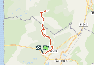

Lengte
6,9 km

Max. hoogte
139 m

Positief hoogteverschil
123 m
Km-Effort
8,5 km

Min. hoogte
25 m

Negatief hoogteverschil
123 m
Boucle
Ja
Datum van aanmaak :
2022-08-08 12:57:08.0
Laatste wijziging :
2022-08-08 15:31:48.175
2h34
Moeilijkheid : Medium

Gratisgps-wandelapplicatie
 SityTrail
IGN / Geografische instituten
SityTrail Plus
De wereld gaat voor u open
Over ons
Tocht Stappen van 6,9 km beschikbaar op Hauts-de-France, Pas-de-Calais, Dannes. Deze tocht wordt voorgesteld door Lustucru.
Beschrijving
Difficile
Attention aux chutes
Plaatsbepaling
Land:
France
Regio :
Hauts-de-France
Departement/Provincie :
Pas-de-Calais
Gemeente :
Dannes
Locatie:
Unknown
Vertrek:(Dec)
Vertrek:(UTM)
401156 ; 5605369 (31U) N.
Opmerkingen