


38-kms

topolino
Gebruiker
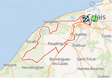

Lengte
38 km

Max. hoogte
149 m

Positief hoogteverschil
517 m
Km-Effort
45 km

Min. hoogte
-4 m

Negatief hoogteverschil
518 m
Boucle
Ja
Datum van aanmaak :
2022-08-12 16:06:09.058
Laatste wijziging :
2022-08-12 16:06:09.058
3h08
Moeilijkheid : Zeer moeilijk

Gratisgps-wandelapplicatie
 SityTrail
IGN / Geografische instituten
SityTrail Plus
De wereld gaat voor u open
Over ons
Tocht Mountainbike van 38 km beschikbaar op Hauts-de-France, Pas-de-Calais, Calais. Deze tocht wordt voorgesteld door topolino.
Plaatsbepaling
Land:
France
Regio :
Hauts-de-France
Departement/Provincie :
Pas-de-Calais
Gemeente :
Calais
Locatie:
Unknown
Vertrek:(Dec)
Vertrek:(UTM)
418542 ; 5643745 (31U) N.
Opmerkingen