


roc-opale-65-km

topolino
Gebruiker
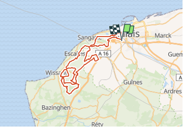

Lengte
64 km

Max. hoogte
163 m

Positief hoogteverschil
1059 m
Km-Effort
78 km

Min. hoogte
-3 m

Negatief hoogteverschil
1060 m
Boucle
Ja
Datum van aanmaak :
2022-08-12 16:12:08.361
Laatste wijziging :
2022-08-12 16:12:08.361
5h26
Moeilijkheid : Zeer moeilijk

Gratisgps-wandelapplicatie
 SityTrail
IGN / Geografische instituten
SityTrail Plus
De wereld gaat voor u open
Over ons
Tocht Mountainbike van 64 km beschikbaar op Hauts-de-France, Pas-de-Calais, Calais. Deze tocht wordt voorgesteld door topolino.
Beschrijving
roc opale 65 km 2019
Plaatsbepaling
Land:
France
Regio :
Hauts-de-France
Departement/Provincie :
Pas-de-Calais
Gemeente :
Calais
Locatie:
Unknown
Vertrek:(Dec)
Vertrek:(UTM)
418476 ; 5643751 (31U) N.
Opmerkingen