


5 juil. 2021 09:15:10 aigoual

ARVIEU
Gebruiker
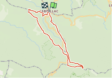

Lengte
17,8 km

Max. hoogte
1569 m

Positief hoogteverschil
644 m
Km-Effort
26 km

Min. hoogte
1169 m

Negatief hoogteverschil
647 m
Boucle
Ja
Datum van aanmaak :
2022-08-14 05:08:39.468
Laatste wijziging :
2022-08-14 05:09:51.172
5h00
Moeilijkheid : Moeilijk

Gratisgps-wandelapplicatie
 SityTrail
IGN / Geografische instituten
SityTrail Plus
De wereld gaat voor u open
Over ons
Tocht Stappen van 17,8 km beschikbaar op Occitanië, Lozère, Rousses. Deze tocht wordt voorgesteld door ARVIEU.
Plaatsbepaling
Land:
France
Regio :
Occitanië
Departement/Provincie :
Lozère
Gemeente :
Rousses
Locatie:
Unknown
Vertrek:(Dec)
Vertrek:(UTM)
543951 ; 4890297 (31T) N.
Opmerkingen