


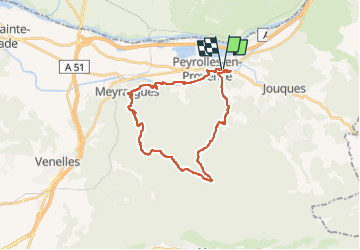
Peyrolles Joucques

phugues
Gebruiker

Lengte
27 km

Max. hoogte
554 m

Positief hoogteverschil
640 m
Km-Effort
35 km

Min. hoogte
211 m

Negatief hoogteverschil
640 m
Boucle
Ja
Datum van aanmaak :
2022-08-15 07:27:32.952
Laatste wijziging :
2022-08-15 09:32:45.554
2h04
Moeilijkheid : Moeilijk

Gratisgps-wandelapplicatie
 SityTrail
IGN / Geografische instituten
SityTrail Plus
De wereld gaat voor u open
Over ons
Tocht Mountainbike van 27 km beschikbaar op Provence-Alpes-Côte d'Azur, Bouches-du-Rhône, Peyrolles-en-Provence. Deze tocht wordt voorgesteld door phugues.
Plaatsbepaling
Land:
France
Regio :
Provence-Alpes-Côte d'Azur
Departement/Provincie :
Bouches-du-Rhône
Gemeente :
Peyrolles-en-Provence
Locatie:
Unknown
Vertrek:(Dec)
Vertrek:(UTM)
709266 ; 4835914 (31T) N.
Opmerkingen