Tocht Stappen Lugano - Circuit decouverte Lugano - Photo

Circuit decouverte Lugano

 chessyca
chessyca

Gebruiker

© OpenStreetMap contributors
Lengte
Lengte
25 km
Max. hoogte
Max. hoogte
923 m
Positief hoogteverschil
1167 m
Km-Effort
Km-Effort  
40 km
Min. hoogte
Min. hoogte
272 m
Negatief hoogteverschil
1174 m
Boucle
Boucle
Ja
Datum van aanmaak :
2022-08-19 07:08:24.867
Laatste wijziging :
2022-08-19 18:35:19.49

(0 Bericht)

Stappen
Stappen
5h42
Moeilijkheid : Medium

Scan deze QR-code om de tocht te openen in de SityTrail-applicatie

Gratisgps-wandelapplicatie

Logo SityTrail SityTrail

IGN / Geografische instituten

SityTrail uit de App Store downloaden SityTrail uit Google Play downloaden

Logo SityTrail SityTrail World

De wereld gaat voor u open

SityTrail uit de App Store downloaden SityTrail uit Google Play downloaden SityTrail op Huawei AppGallery downloaden

Over ons

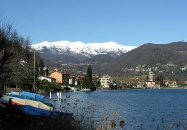
Tocht Stappen van 25 km beschikbaar op Ticino, Distretto di Lugano, Lugano. Deze tocht wordt voorgesteld door chessyca.

Beschrijving

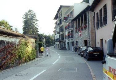
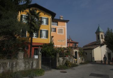
Visite de la partie historique de la ville puis
suivi du sentier des oliviers
et enfin montée via le funiculaire du Monté Bré

Il faut retirer à cette rando 4km et 600 mètres de dénivelés


comprend le sentier des oliviers et la montee au funiculaire
vrai denivele 450 m

Hoogteprofiel

Foto's

Plaatsbepaling

Land:
Switzerland
Regio :
Ticino
Departement/Provincie :
Distretto di Lugano
Gemeente :
Lugano
Locatie:
Unknown
Vertrek:(UTM)
495969 ; 5093863 (32T) N.

Wandeltochten in de omgeving

Tocht Te voet Caslano - Giro/Tour Monte Caslano - Photo
Te voet
PRO

Te voet

Gemakkelijk
Caslano, Ticino, Distretto di Lugano, Switzerland
4,4 km | 6 km-effort
1h 21min
Ja
Tocht Te voet Melide - Melide-Vico Morcote - Photo
Te voet
PRO

Te voet

Gemakkelijk
Melide, Ticino, Distretto di Lugano, Switzerland
4,1 km | 6,6 km-effort
1h 30min
Neen
Tocht Te voet Lugano - Carona-Alpe Vicania - Photo
Te voet
PRO

Te voet

Gemakkelijk
Lugano, Ticino, Distretto di Lugano, Switzerland
3,8 km | 5,9 km-effort
1h 20min
Neen
Tocht Te voet Paradiso - Paradiso-San Salvatore - Photo
Te voet
PRO

Te voet

Gemakkelijk
Paradiso, Ticino, Distretto di Lugano, Switzerland
3,2 km | 9,1 km-effort
2h 3min
Neen
Tocht Andere activiteiten Paradiso - y10_hoehenweg_luganersee - Photo
Andere activiteiten
GUIDE+

Andere activiteiten

Heel gemakkelijk
Paradiso, Ticino, Distretto di Lugano, Switzerland
12,2 km | 22 km-effort
5h 16min
Neen
Tocht Andere activiteiten Lugano - y10_monte_boglia - Photo
Andere activiteiten
GUIDE+

Andere activiteiten

Heel gemakkelijk
Lugano, Ticino, Distretto di Lugano, Switzerland
13,1 km | 32 km-effort
7h 5min
Neen
Tocht Mountainbike Lugano - Bike32933 - Photo
Mountainbike
GUIDE+

Mountainbike

Heel gemakkelijk
Lugano, Ticino, Distretto di Lugano, Switzerland
25 km | 38 km-effort
Onbekend
Ja
Tocht Mountainbike Magliaso - Bike32929 - Photo
Mountainbike
GUIDE+

Mountainbike

Heel gemakkelijk
Magliaso, Ticino, Distretto di Lugano, Switzerland
29 km | 44 km-effort
Onbekend
Ja
Tocht Stappen Alto Malcantone - Caslano: Kastanienweg - Photo
Stappen
GUIDE+

Stappen

Heel gemakkelijk
Alto Malcantone, Ticino, Distretto di Lugano, Switzerland
11,1 km | 16,4 km-effort
Onbekend
Neen


Sluiten
Mijn abonnementen