


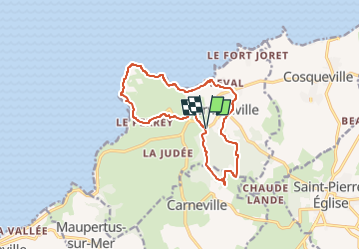
Fermanville- Le cap Lévi

JMCMoreau
Gebruiker

Lengte
12,5 km

Max. hoogte
83 m

Positief hoogteverschil
174 m
Km-Effort
14,8 km

Min. hoogte
-1 m

Negatief hoogteverschil
174 m
Boucle
Ja
Datum van aanmaak :
2022-08-19 16:42:51.443
Laatste wijziging :
2022-08-19 16:44:06.928
3h30
Moeilijkheid : Medium

Gratisgps-wandelapplicatie
 SityTrail
IGN / Geografische instituten
SityTrail Plus
De wereld gaat voor u open
Over ons
Tocht Stappen van 12,5 km beschikbaar op Normandië, Manche, Fermanville. Deze tocht wordt voorgesteld door JMCMoreau.
Plaatsbepaling
Land:
France
Regio :
Normandië
Departement/Provincie :
Manche
Gemeente :
Fermanville
Locatie:
Unknown
Vertrek:(Dec)
Vertrek:(UTM)
612001 ; 5504526 (30U) N.
Opmerkingen