


2022 08 23 Chatel BF

bstebe
Gebruiker
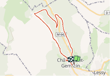

Lengte
7,5 km

Max. hoogte
345 m

Positief hoogteverschil
178 m
Km-Effort
9,9 km

Min. hoogte
201 m

Negatief hoogteverschil
175 m
Boucle
Ja
Datum van aanmaak :
2022-08-23 07:10:54.28
Laatste wijziging :
2022-08-23 09:26:10.382
2h14
Moeilijkheid : Medium

Gratisgps-wandelapplicatie
 SityTrail
IGN / Geografische instituten
SityTrail Plus
De wereld gaat voor u open
Over ons
Tocht Stappen van 7,5 km beschikbaar op Grand Est, Moselle, Châtel-Saint-Germain. Deze tocht wordt voorgesteld door bstebe.
Plaatsbepaling
Land:
France
Regio :
Grand Est
Departement/Provincie :
Moselle
Gemeente :
Châtel-Saint-Germain
Locatie:
Unknown
Vertrek:(Dec)
Vertrek:(UTM)
286989 ; 5445202 (32U) N.
Opmerkingen