


Dan47 Bois de Villers

istadaniel
Gebruiker
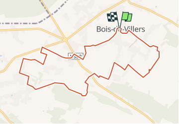

Lengte
10,8 km

Max. hoogte
265 m

Positief hoogteverschil
176 m
Km-Effort
13,1 km

Min. hoogte
193 m

Negatief hoogteverschil
175 m
Boucle
Ja
Datum van aanmaak :
2022-09-01 10:05:45.429
Laatste wijziging :
2022-12-16 10:45:51.83
2h58
Moeilijkheid : Gemakkelijk

Gratisgps-wandelapplicatie
 SityTrail
IGN / Geografische instituten
SityTrail Plus
De wereld gaat voor u open
Over ons
Tocht Te voet van 10,8 km beschikbaar op Wallonië, Namen, Profondeville. Deze tocht wordt voorgesteld door istadaniel.
Plaatsbepaling
Land:
Belgium
Regio :
Wallonië
Departement/Provincie :
Namen
Gemeente :
Profondeville
Locatie:
Bois-de-Villers
Vertrek:(Dec)
Vertrek:(UTM)
629599 ; 5583589 (31U) N.
Opmerkingen