


Plassac-Becheresse

jmrobin
Gebruiker
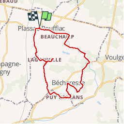

Lengte
15,6 km

Max. hoogte
188 m

Positief hoogteverschil
272 m
Km-Effort
19,2 km

Min. hoogte
99 m

Negatief hoogteverschil
273 m
Boucle
Ja
Datum van aanmaak :
2019-03-04 10:38:15.226
Laatste wijziging :
2019-03-04 10:38:15.257
3h13
Moeilijkheid : Gemakkelijk

Gratisgps-wandelapplicatie
 SityTrail
IGN / Geografische instituten
SityTrail Plus
De wereld gaat voor u open
Over ons
Tocht Stappen van 15,6 km beschikbaar op Nieuw-Aquitanië, Charente, Plassac-Rouffiac. Deze tocht wordt voorgesteld door jmrobin.
Plaatsbepaling
Land:
France
Regio :
Nieuw-Aquitanië
Departement/Provincie :
Charente
Gemeente :
Plassac-Rouffiac
Locatie:
Unknown
Vertrek:(Dec)
Vertrek:(UTM)
270694 ; 5045758 (31T) N.
Opmerkingen