Tocht Mountainbike Virton - Les trois éperons barrés  -  Balade_VTT_34kms - Photo

Les trois éperons barrés - Balade_VTT_34kms

 Pascal L
Pascal L

Gebruiker

© OpenStreetMap contributors
Lengte
Lengte
34 km
Max. hoogte
Max. hoogte
364 m
Positief hoogteverschil
627 m
Km-Effort
Km-Effort  
42 km
Min. hoogte
Min. hoogte
208 m
Negatief hoogteverschil
627 m
Boucle
Boucle
Ja
Datum van aanmaak :
2022-09-05 08:13:01.869
Laatste wijziging :
2022-12-01 17:51:00.063

(0 Bericht)

Mountainbike
Mountainbike
3h18
Moeilijkheid : Moeilijk

Scan deze QR-code om de tocht te openen in de SityTrail-applicatie

Gratisgps-wandelapplicatie

Logo SityTrail SityTrail

IGN / Geografische instituten

SityTrail uit de App Store downloaden SityTrail uit Google Play downloaden

Logo SityTrail SityTrail World

De wereld gaat voor u open

SityTrail uit de App Store downloaden SityTrail uit Google Play downloaden SityTrail op Huawei AppGallery downloaden

Over ons

Tocht Mountainbike van 34 km beschikbaar op Wallonië, Luxemburg, Virton. Deze tocht wordt voorgesteld door Pascal L.

Beschrijving

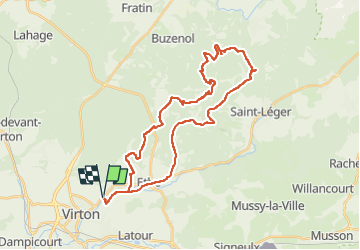
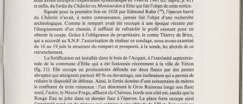
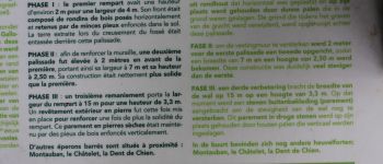
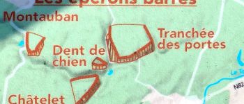
Cette balade intrépide vous conduit sur trois éperons barrés : le "Châtelet" à Ethe, la "Dent de Chien" à Buzenol et la "Tranchée des Portes" à Etalle. Il s'agit d'un système de défense vaste datant de l'âge du fer (époque protohistorique, celtique, gauloise) qui comprenait aussi le célèbre promontoire de "Montauban" de Buzenol.

Départ/Retour: Virton (Pierrard)
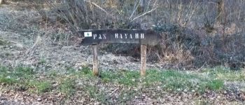
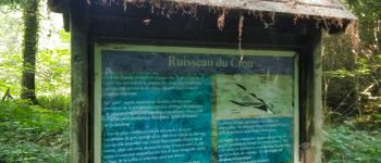
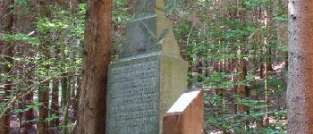
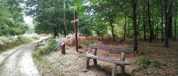
Endroits de passage : Ravel (ligne 155), Belmont, Rue de Belle Vue, le Chenoi, Ruisseau du Chou, Ourdon, Ravel (ligne 155), Bois de l'Acquêt, Montourdon et sa grotte, la Neuve Forge et son ruisseau, le ruisseau la Rouge Eau, la Dent de Chien (escalade et exploration), Têtes des Ronces, Bois d'Etalle, pompages et réservoir, Tranchée des Portes (exploration), Haie de Han de St-Léger, La Cuisine Sauvage, Vertes Voies, Croix Célestin, Bois d'Ahérée, Bois de St-Léger, Croix la Cloutière, Voie des Bourriques, Croix Renson, pont et ruisseau de la Neuve Forge, vallée et ruisseau de Laclaireau, Ethe, Ravel (ligne 155).

Vidéo: https://vimeo.com/747303091   (La Rouge Eau à la Cuisine Sauvage)

PI:
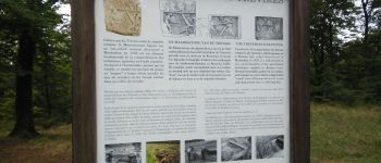
1) Châtelet : https://www.sitytrail.com/fr/poi/20971328-virton--le-chatelet-a-ethe
2) Dent de Chien : https://www.sitytrail.com/fr/poi/21039815-etalle--dent-de-chien-a-buzenol/
3) Tranchée des Portes : https://www.sitytrail.com/fr/poi/20973435-etalle--la-tranchee-des-portes-a-etalle/
4) Montauban : https://www.sitytrail.com/fr/poi/20730527-etalle--site-galloxromain-et-cron-de-montauban

Ref.
- https://www.virton.be/loisirs/culture/breve-histoire-de-virton
- https://www.facebook.com/Cuisine-Sauvage-A-la-Rouge-Eau-1517051368597020/
- http://biodiversite.wallonie.be/fr/2373-vallee-de-la-rouge-eau.html?IDD=251660568&IDC=1881

(2022.09.05)

Hoogteprofiel

Foto's

85 fotos in totaal. Klik op een foto om ze allemaal in de galerij weer te geven.

POI's

POI Virton - Pas Bayard à Virton - Photo
Pascal L
POI Virton - Ruisseau du Cron - Photo
Pascal L
POI Virton - Unnamed POI - Photo
Pascal L
VIRTON 
POI Virton - Croix Renson - Photo
Pascal L
VIRTON 
POI Saint-Léger - Croix du Taureau - Photo
Pascal L
SAINT-LÉGER 
POI Virton - Le Châtelet à Ethe - Photo
Pascal L
POI Saint-Léger - Croix la Cloutière - Photo
Pascal L
SAINT-LÉGER 
POI Étalle - Dent de Chien à Buzenol - Photo
Pascal L

Plaatsbepaling

Land:
Belgium
Regio :
Wallonië
Departement/Provincie :
Luxemburg
Gemeente :
Virton
Locatie:
Virton
Vertrek:(UTM)
684243 ; 5494502 (31U) N.

Wandeltochten in de omgeving

Tocht Stappen Virton - RB-Lu-17_Ethe_via-var-1-et-2-et-3 - Photo
Stappen
PRO

Stappen

Heel gemakkelijk
(3)
Virton, Wallonië, Luxemburg, Belgium
29 km | 35 km-effort
7h 33min
Ja
Tocht Mountainbike Virton - T2019-06-16-16-47 - Photo
Mountainbike
Pascal L

Mountainbike

Gemakkelijk
(1)
Virton, Wallonië, Luxemburg, Belgium
21 km | 26 km-effort
1h 40min
Ja
Tocht Stappen Virton - GAUME Balade  naturelle et historique - Photo
Stappen
julucasi

Stappen

Heel gemakkelijk
(1)
Virton, Wallonië, Luxemburg, Belgium
5,2 km | 6,8 km-effort
1h 16min
Ja
Tocht Te voet Virton - La Bajocienne - Photo
Te voet
GUIDE+

Te voet

Gemakkelijk
(1)
Virton, Wallonië, Luxemburg, Belgium
11 km | 14,5 km-effort
3h 17min
Ja
Tocht Te voet Virton - Chenois-Latour - Agrarische wandeling -  dorpen, appels en klein fruit - Photo
Te voet
GUIDE
DUPONT Rita

Te voet

Gemakkelijk
Virton, Wallonië, Luxemburg, Belgium
6,4 km | 7,7 km-effort
1h 45min
Ja
Tocht Stappen Virton - RB-Lu-17_Ethe_via-racc - Photo
Stappen
PRO

Stappen

Heel gemakkelijk
Virton, Wallonië, Luxemburg, Belgium
15,6 km | 19,3 km-effort
4h 8min
Ja
Tocht Stappen Virton - RB-Lu-17_Ethe - Photo
Stappen
PRO

Stappen

Heel gemakkelijk
Virton, Wallonië, Luxemburg, Belgium
22 km | 28 km-effort
5h 55min
Ja
Tocht Mountainbike Virton - Autour de Tintigny  -  Balade_VTT_54Kms - Photo
Mountainbike
Pascal L

Mountainbike

Zeer moeilijk
Virton, Wallonië, Luxemburg, Belgium
54 km | 64 km-effort
4h 25min
Ja
Tocht Mountainbike Virton - Monquintin  -  Balade_VTT_22Kms - Photo
Mountainbike
Pascal L

Mountainbike

Medium
Virton, Wallonië, Luxemburg, Belgium
22 km | 26 km-effort
1h 48min
Ja


Sluiten
Mijn abonnementen