


Chemin de la Mature en boucle

Prala
Gebruiker
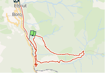

Lengte
14,1 km

Max. hoogte
1309 m

Positief hoogteverschil
881 m
Km-Effort
26 km

Min. hoogte
594 m

Negatief hoogteverschil
937 m
Boucle
Neen
Datum van aanmaak :
2022-09-06 08:52:52.798
Laatste wijziging :
2022-09-06 15:31:15.441
3h36
Moeilijkheid : Gemakkelijk

Gratisgps-wandelapplicatie
 SityTrail
IGN / Geografische instituten
SityTrail Plus
De wereld gaat voor u open
Over ons
Tocht Stappen van 14,1 km beschikbaar op Nieuw-Aquitanië, Pyrénées-Atlantiques, Etsaut. Deze tocht wordt voorgesteld door Prala.
Beschrijving
Chemin de la Mature en boucle par le col d'Arras
Plaatsbepaling
Land:
France
Regio :
Nieuw-Aquitanië
Departement/Provincie :
Pyrénées-Atlantiques
Gemeente :
Etsaut
Locatie:
Unknown
Vertrek:(Dec)
Vertrek:(UTM)
698709 ; 4752316 (30T) N.
Opmerkingen