


2022 09 13 Gorze jplm

bstebe
Gebruiker
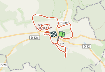

Lengte
8,7 km

Max. hoogte
281 m

Positief hoogteverschil
229 m
Km-Effort
11,7 km

Min. hoogte
203 m

Negatief hoogteverschil
233 m
Boucle
Ja
Datum van aanmaak :
2022-09-13 12:02:18.174
Laatste wijziging :
2024-04-04 09:50:30.893
2h39
Moeilijkheid : Medium

Gratisgps-wandelapplicatie
 SityTrail
IGN / Geografische instituten
SityTrail Plus
De wereld gaat voor u open
Over ons
Tocht Stappen van 8,7 km beschikbaar op Grand Est, Moselle, Gorze. Deze tocht wordt voorgesteld door bstebe.
Plaatsbepaling
Land:
France
Regio :
Grand Est
Departement/Provincie :
Moselle
Gemeente :
Gorze
Locatie:
Unknown
Vertrek:(Dec)
Vertrek:(UTM)
719081 ; 5437645 (31U) N.
Opmerkingen