


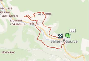
SityTrail - 422114 - corniche-du-creneau-salle-la-source

leboucherdaniel
Gebruiker

Lengte
9 km

Max. hoogte
512 m

Positief hoogteverschil
266 m
Km-Effort
12,6 km

Min. hoogte
327 m

Negatief hoogteverschil
278 m
Boucle
Ja
Datum van aanmaak :
2022-09-19 20:10:05.0
Laatste wijziging :
2022-09-19 20:10:07.937

Gratisgps-wandelapplicatie
 SityTrail
IGN / Geografische instituten
SityTrail Plus
De wereld gaat voor u open
Over ons
Tocht van 9 km beschikbaar op Occitanië, Aveyron, Salles-la-Source. Deze tocht wordt voorgesteld door leboucherdaniel.
Plaatsbepaling
Land:
France
Regio :
Occitanië
Departement/Provincie :
Aveyron
Gemeente :
Salles-la-Source
Locatie:
Unknown
Vertrek:(Dec)
Vertrek:(UTM)
461378 ; 4920501 (31T) N.
Opmerkingen