


Monthou sur Cher

Pascal Bernaud
Gebruiker
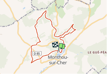

Lengte
8,9 km

Max. hoogte
111 m

Positief hoogteverschil
107 m
Km-Effort
10,3 km

Min. hoogte
68 m

Negatief hoogteverschil
110 m
Boucle
Ja
Datum van aanmaak :
2022-10-04 07:05:41.0
Laatste wijziging :
2022-10-04 09:02:08.26
1h56
Moeilijkheid : Onbekend

Gratisgps-wandelapplicatie
 SityTrail
IGN / Geografische instituten
SityTrail Plus
De wereld gaat voor u open
Over ons
Tocht Noords wandelen van 8,9 km beschikbaar op Centre-Val de Loire, Loir-et-Cher, Monthou-sur-Cher. Deze tocht wordt voorgesteld door Pascal Bernaud.
Plaatsbepaling
Land:
France
Regio :
Centre-Val de Loire
Departement/Provincie :
Loir-et-Cher
Gemeente :
Monthou-sur-Cher
Locatie:
Unknown
Vertrek:(Dec)
Vertrek:(UTM)
371129 ; 5245388 (31T) N.
Opmerkingen