


Q1

aldaus
Gebruiker
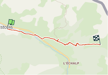

Lengte
5,4 km

Max. hoogte
2128 m

Positief hoogteverschil
525 m
Km-Effort
10,7 km

Min. hoogte
1610 m

Negatief hoogteverschil
15 m
Boucle
Neen
Datum van aanmaak :
2022-10-01 13:46:50.435
Laatste wijziging :
2022-10-04 15:20:53.816
1h57
Moeilijkheid : Gemakkelijk

Gratisgps-wandelapplicatie
 SityTrail
IGN / Geografische instituten
SityTrail Plus
De wereld gaat voor u open
Over ons
Tocht Stappen van 5,4 km beschikbaar op Provence-Alpes-Côte d'Azur, Hautes-Alpes, Abriès-Ristolas. Deze tocht wordt voorgesteld door aldaus.
Plaatsbepaling
Land:
France
Regio :
Provence-Alpes-Côte d'Azur
Departement/Provincie :
Hautes-Alpes
Gemeente :
Abriès-Ristolas
Locatie:
Unknown
Vertrek:(Dec)
Vertrek:(UTM)
338369 ; 4959791 (32T) N.
Opmerkingen