


Q2

aldaus
Gebruiker
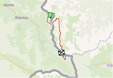

Lengte
14,1 km

Max. hoogte
2831 m

Positief hoogteverschil
1350 m
Km-Effort
31 km

Min. hoogte
1707 m

Negatief hoogteverschil
971 m
Boucle
Neen
Datum van aanmaak :
2022-10-02 06:32:18.764
Laatste wijziging :
2022-10-04 15:20:57.28
6h51
Moeilijkheid : Medium

Gratisgps-wandelapplicatie
 SityTrail
IGN / Geografische instituten
SityTrail Plus
De wereld gaat voor u open
Over ons
Tocht Stappen van 14,1 km beschikbaar op Provence-Alpes-Côte d'Azur, Hautes-Alpes, Abriès-Ristolas. Deze tocht wordt voorgesteld door aldaus.
Plaatsbepaling
Land:
France
Regio :
Provence-Alpes-Côte d'Azur
Departement/Provincie :
Hautes-Alpes
Gemeente :
Abriès-Ristolas
Locatie:
Ristolas
Vertrek:(Dec)
Vertrek:(UTM)
342646 ; 4958934 (32T) N.
Opmerkingen