


Étangs Minière

Rando MLC
Gebruiker
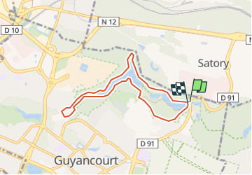

Lengte
6,6 km

Max. hoogte
162 m

Positief hoogteverschil
93 m
Km-Effort
7,9 km

Min. hoogte
126 m

Negatief hoogteverschil
95 m
Boucle
Ja
Datum van aanmaak :
2022-10-09 07:48:35.582
Laatste wijziging :
2022-10-11 09:35:34.459
5h03
Moeilijkheid : Moeilijk

Gratisgps-wandelapplicatie
 SityTrail
IGN / Geografische instituten
SityTrail Plus
De wereld gaat voor u open
Over ons
Tocht Stappen van 6,6 km beschikbaar op Île-de-France, Yvelines, Guyancourt. Deze tocht wordt voorgesteld door Rando MLC.
Plaatsbepaling
Land:
France
Regio :
Île-de-France
Departement/Provincie :
Yvelines
Gemeente :
Guyancourt
Locatie:
Unknown
Vertrek:(Dec)
Vertrek:(UTM)
433601 ; 5403438 (31U) N.
Opmerkingen