


GR123

ORTAX
Gebruiker
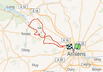

Lengte
53 km

Max. hoogte
99 m

Positief hoogteverschil
525 m
Km-Effort
60 km

Min. hoogte
10 m

Negatief hoogteverschil
525 m
Boucle
Ja
Datum van aanmaak :
2022-10-12 05:53:29.0
Laatste wijziging :
2022-10-12 05:53:32.246
4h09
Moeilijkheid : Gemakkelijk

Gratisgps-wandelapplicatie
 SityTrail
IGN / Geografische instituten
SityTrail Plus
De wereld gaat voor u open
Over ons
Tocht Mountainbike van 53 km beschikbaar op Hauts-de-France, Somme, Amiens. Deze tocht wordt voorgesteld door ORTAX.
Plaatsbepaling
Land:
France
Regio :
Hauts-de-France
Departement/Provincie :
Somme
Gemeente :
Amiens
Locatie:
Unknown
Vertrek:(Dec)
Vertrek:(UTM)
448503 ; 5527347 (31U) N.
Opmerkingen