Tocht Stappen Pourcieux - 2022-11-11_17h53m46_pourcieux - Photo

2022-11-11_17h53m46_pourcieux

 Levant
Levant

Gebruiker

© OpenStreetMap contributors
Lengte
Lengte
18,2 km
Max. hoogte
Max. hoogte
874 m
Positief hoogteverschil
733 m
Km-Effort
Km-Effort  
28 km
Min. hoogte
Min. hoogte
354 m
Negatief hoogteverschil
733 m
Boucle
Boucle
Ja
Datum van aanmaak :
2022-11-11 16:53:47.993
Laatste wijziging :
2022-11-13 11:02:05.914

(1 Bericht)

Stappen
Stappen
6h21
Moeilijkheid : Zeer moeilijk

Scan deze QR-code om de tocht te openen in de SityTrail-applicatie

Gratisgps-wandelapplicatie

Logo SityTrail SityTrail

IGN / Geografische instituten

SityTrail uit de App Store downloaden SityTrail uit Google Play downloaden

Logo SityTrail SityTrail World

De wereld gaat voor u open

SityTrail uit de App Store downloaden SityTrail uit Google Play downloaden SityTrail op Huawei AppGallery downloaden

Over ons

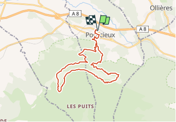
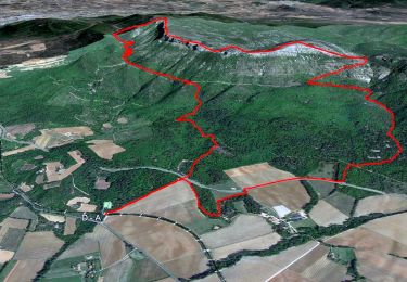
Tocht Stappen van 18,2 km beschikbaar op Provence-Alpes-Côte d'Azur, Var, Pourcieux. Deze tocht wordt voorgesteld door Levant .

Beschrijving

Départ du village de Pourcieux
La coquille
Rejoindre le chemin des contrebandiers
Gagner les crêtes par le collet Redon
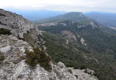
Suivre la crête du Mont Aurélien du Pas des Ifs jusqu'au bout de L'Olympe
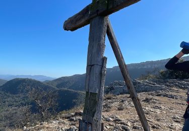
Visite des vestiges Archéologiques
Retour vers Pourcieux

Hoogteprofiel

Plaatsbepaling

Land:
France
Regio :
Provence-Alpes-Côte d'Azur
Departement/Provincie :
Var
Gemeente :
Pourcieux
Locatie:
Unknown
Vertrek:(UTM)
725223 ; 4816898 (31T) N.

Opmerkingen

Gelieve in te loggen om een commentaar of een beoordeling achter te laten


Wandeltochten in de omgeving

Tocht Stappen Pourrières - JPS Monts  Aurélien-17655561 - Photo
Stappen
GUIDE
affinetataille

Stappen

Medium
(1)
Pourrières, Provence-Alpes-Côte d'Azur, Var, France
17,3 km | 27 km-effort
7h 0min
Ja
Tocht Stappen Pourcieux - pas des iifs - Photo
Stappen
coureurdegarrigue

Stappen

Gemakkelijk
(1)
Pourcieux, Provence-Alpes-Côte d'Azur, Var, France
15,8 km | 24 km-effort
5h 55min
Ja
Tocht Stappen Pourrières - Mt Olympe et le pas du Titet - Photo
Stappen
ETMU5496

Stappen

Moeilijk
Pourrières, Provence-Alpes-Côte d'Azur, Var, France
19,9 km | 32 km-effort
7h 15min
Ja
Tocht Stappen Pourcieux - 2024-03-02_17h01m33_La chouette d'Or Pourcieux - Photo
Stappen

Stappen

Medium
(1)
Pourcieux, Provence-Alpes-Côte d'Azur, Var, France
7,2 km | 11,9 km-effort
2h 41min
Ja
Tocht Stappen Trets - SityTrail - mont olympe + crête  - Photo
Stappen
frizou83

Stappen

Zeer moeilijk
(1)
Trets, Provence-Alpes-Côte d'Azur, Bouches-du-Rhône, France
13 km | 21 km-effort
4h 44min
Ja
Tocht Stappen Pourrières - Pourcieux :Mont Olympe et Pas du Titet - Photo
Stappen
ETMU5496

Stappen

Zeer moeilijk
(1)
Pourrières, Provence-Alpes-Côte d'Azur, Var, France
20 km | 32 km-effort
7h 22min
Neen
Tocht Stappen Pourcieux - Pourcieux - ¨Pas des Ifs, de la Croix et de Titet - Olympe - Rocher de Onze Heures - Croix de Pourcieux - Photo
Stappen
LtZIP

Stappen

Moeilijk
Pourcieux, Provence-Alpes-Côte d'Azur, Var, France
19,2 km | 30 km-effort
4h 49min
Ja
Tocht Stappen Pourcieux - Croix de pourcieux - Photo
Stappen
gaggiroland

Stappen

Moeilijk
Pourcieux, Provence-Alpes-Côte d'Azur, Var, France
9,9 km | 15 km-effort
3h 31min
Ja
Tocht Stappen Pourcieux - Crêtes du Mont Aurélien - Photo
Stappen
ETMU5496

Stappen

Moeilijk
Pourcieux, Provence-Alpes-Côte d'Azur, Var, France
19,4 km | 30 km-effort
4h 37min
Ja


Sluiten
Mijn abonnementen