


Col de l'Evéque - Pic de l'Ours

soca
Gebruiker

Lengte
9,2 km

Max. hoogte
429 m

Positief hoogteverschil
595 m
Km-Effort
17,1 km

Min. hoogte
26 m

Negatief hoogteverschil
595 m
Boucle
Ja
Datum van aanmaak :
2022-11-21 19:26:59.975
Laatste wijziging :
2022-11-21 19:37:31.512
5h00
Moeilijkheid : Moeilijk

Gratisgps-wandelapplicatie
 SityTrail
IGN / Geografische instituten
SityTrail Plus
De wereld gaat voor u open
Over ons
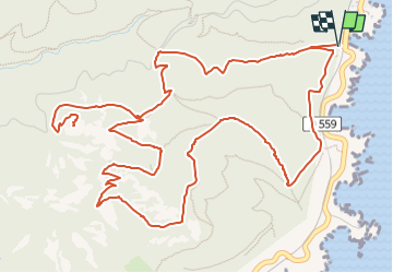
Tocht Stappen van 9,2 km beschikbaar op Provence-Alpes-Côte d'Azur, Var, Saint-Raphaël. Deze tocht wordt voorgesteld door soca.
Beschrijving
Départ Calanque d'Aurelle - Col de l'Evêque - Grotte chapelle St Honoré - Retour En dessous du Pilon - pointe de Maubois - Calanque d'Aurelle
Plaatsbepaling
Land:
France
Regio :
Provence-Alpes-Côte d'Azur
Departement/Provincie :
Var
Gemeente :
Saint-Raphaël
Locatie:
Unknown
Vertrek:(Dec)
Vertrek:(UTM)
331808 ; 4814184 (32T) N.
Opmerkingen