


25/11/2022 - Gavrain à ST Ganton

babeth35
Gebruiker
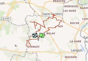

Lengte
23 km

Max. hoogte
106 m

Positief hoogteverschil
269 m
Km-Effort
26 km

Min. hoogte
25 m

Negatief hoogteverschil
269 m
Boucle
Ja
Datum van aanmaak :
2022-11-25 07:25:01.0
Laatste wijziging :
2022-11-25 15:11:38.137
5h39
Moeilijkheid : Medium

Gratisgps-wandelapplicatie
 SityTrail
IGN / Geografische instituten
SityTrail Plus
De wereld gaat voor u open
Over ons
Tocht Stappen van 23 km beschikbaar op Bretagne, Ille-et-Vilaine, Langon. Deze tocht wordt voorgesteld door babeth35.
Plaatsbepaling
Land:
France
Regio :
Bretagne
Departement/Provincie :
Ille-et-Vilaine
Gemeente :
Langon
Locatie:
Unknown
Vertrek:(Dec)
Vertrek:(UTM)
582214 ; 5286819 (30T) N.
Opmerkingen