


condé

LaurentBernard
Gebruiker

Lengte
5,7 km

Max. hoogte
61 m

Positief hoogteverschil
35 m
Km-Effort
6,2 km

Min. hoogte
43 m

Negatief hoogteverschil
36 m
Boucle
Ja
Datum van aanmaak :
2022-11-28 17:40:24.369
Laatste wijziging :
2022-11-28 17:41:20.413
1h24
Moeilijkheid : Gemakkelijk

Gratisgps-wandelapplicatie
 SityTrail
IGN / Geografische instituten
SityTrail Plus
De wereld gaat voor u open
Over ons
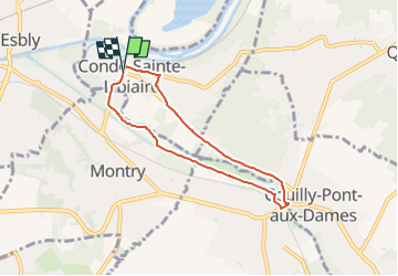
Tocht Te voet van 5,7 km beschikbaar op Île-de-France, Seine-et-Marne, Condé-Sainte-Libiaire. Deze tocht wordt voorgesteld door LaurentBernard.
Plaatsbepaling
Land:
France
Regio :
Île-de-France
Departement/Provincie :
Seine-et-Marne
Gemeente :
Condé-Sainte-Libiaire
Locatie:
Unknown
Vertrek:(Dec)
Vertrek:(UTM)
487483 ; 5416084 (31U) N.
Opmerkingen