


Joucques

PatriceCocuaud
Gebruiker

Lengte
4,8 km

Max. hoogte
365 m

Positief hoogteverschil
143 m
Km-Effort
6,7 km

Min. hoogte
265 m

Negatief hoogteverschil
141 m
Boucle
Ja
Datum van aanmaak :
2022-11-30 12:30:57.414
Laatste wijziging :
2022-11-30 14:20:37.42
1h49
Moeilijkheid : Gemakkelijk

Gratisgps-wandelapplicatie
 SityTrail
IGN / Geografische instituten
SityTrail Plus
De wereld gaat voor u open
Over ons
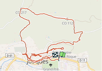
Tocht Stappen van 4,8 km beschikbaar op Provence-Alpes-Côte d'Azur, Bouches-du-Rhône, Jouques. Deze tocht wordt voorgesteld door PatriceCocuaud.
Plaatsbepaling
Land:
France
Regio :
Provence-Alpes-Côte d'Azur
Departement/Provincie :
Bouches-du-Rhône
Gemeente :
Jouques
Locatie:
Unknown
Vertrek:(Dec)
Vertrek:(UTM)
712946 ; 4834935 (31T) N.
Opmerkingen