


lacs de Lognes

LaurentBernard
Gebruiker

Lengte
6,2 km

Max. hoogte
106 m

Positief hoogteverschil
46 m
Km-Effort
6,8 km

Min. hoogte
74 m

Negatief hoogteverschil
48 m
Boucle
Ja
Datum van aanmaak :
2022-12-13 07:51:08.502
Laatste wijziging :
2022-12-13 07:51:45.36
1h32
Moeilijkheid : Gemakkelijk

Gratisgps-wandelapplicatie
 SityTrail
IGN / Geografische instituten
SityTrail Plus
De wereld gaat voor u open
Over ons
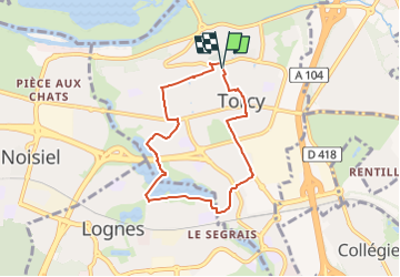
Tocht Te voet van 6,2 km beschikbaar op Île-de-France, Seine-et-Marne, Torcy. Deze tocht wordt voorgesteld door LaurentBernard.
Plaatsbepaling
Land:
France
Regio :
Île-de-France
Departement/Provincie :
Seine-et-Marne
Gemeente :
Torcy
Locatie:
Unknown
Vertrek:(Dec)
Vertrek:(UTM)
474305 ; 5411362 (31U) N.
Opmerkingen