


GR6 - Russan - Le Pont du Gard (parking)

JackyCouturier
Gebruiker
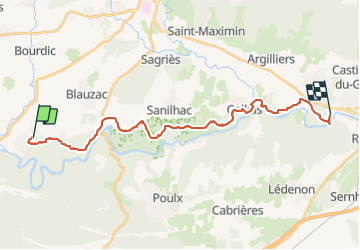

Lengte
25 km

Max. hoogte
182 m

Positief hoogteverschil
456 m
Km-Effort
32 km

Min. hoogte
19 m

Negatief hoogteverschil
527 m
Boucle
Neen
Datum van aanmaak :
2022-12-15 14:49:51.961
Laatste wijziging :
2023-08-19 12:38:01.114
7h13
Moeilijkheid : Moeilijk

Gratisgps-wandelapplicatie
 SityTrail
IGN / Geografische instituten
SityTrail Plus
De wereld gaat voor u open
Over ons
Tocht Te voet van 25 km beschikbaar op Occitanië, Gard, Sainte-Anastasie. Deze tocht wordt voorgesteld door JackyCouturier.
Plaatsbepaling
Land:
France
Regio :
Occitanië
Departement/Provincie :
Gard
Gemeente :
Sainte-Anastasie
Locatie:
Unknown
Vertrek:(Dec)
Vertrek:(UTM)
606877 ; 4866128 (31T) N.
Opmerkingen