


Singles de Gréasque - 30527 - UtagawaVTT.com

Alain Derrives
Gebruiker

Lengte
18,3 km

Max. hoogte
423 m

Positief hoogteverschil
378 m
Km-Effort
23 km

Min. hoogte
323 m

Negatief hoogteverschil
378 m
Boucle
Ja
Datum van aanmaak :
2022-12-22 08:20:22.643
Laatste wijziging :
2022-12-22 08:21:04.421
1h36
Moeilijkheid : Medium

Gratisgps-wandelapplicatie
 SityTrail
IGN / Geografische instituten
SityTrail Plus
De wereld gaat voor u open
Over ons
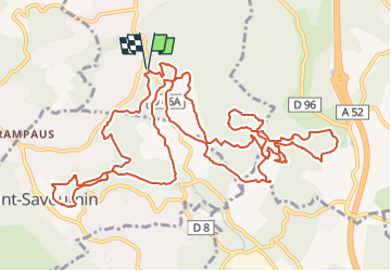
Tocht Mountainbike van 18,3 km beschikbaar op Provence-Alpes-Côte d'Azur, Bouches-du-Rhône, Gréasque. Deze tocht wordt voorgesteld door Alain Derrives.
Plaatsbepaling
Land:
France
Regio :
Provence-Alpes-Côte d'Azur
Departement/Provincie :
Bouches-du-Rhône
Gemeente :
Gréasque
Locatie:
Unknown
Vertrek:(Dec)
Vertrek:(UTM)
705988 ; 4810762 (31T) N.
Opmerkingen