


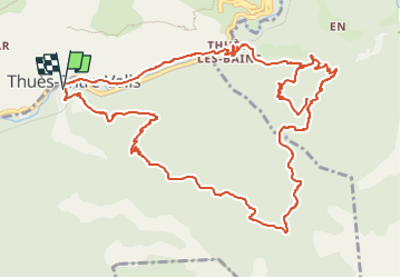
THUES ENTRE VALLS

FAUCET
Gebruiker

Lengte
16,9 km

Max. hoogte
1516 m

Positief hoogteverschil
1115 m
Km-Effort
32 km

Min. hoogte
745 m

Negatief hoogteverschil
1110 m
Boucle
Ja
Datum van aanmaak :
2023-01-03 16:46:59.89
Laatste wijziging :
2023-01-03 16:47:01.475
7h13
Moeilijkheid : Zeer moeilijk

Gratisgps-wandelapplicatie
 SityTrail
IGN / Geografische instituten
SityTrail Plus
De wereld gaat voor u open
Over ons
Tocht Stappen van 16,9 km beschikbaar op Occitanië, Pyrénées-Orientales, Thuès-Entre-Valls. Deze tocht wordt voorgesteld door FAUCET.
Beschrijving
De THUES au refuge d'ARGOUDEIL
Plaatsbepaling
Land:
France
Regio :
Occitanië
Departement/Provincie :
Pyrénées-Orientales
Gemeente :
Thuès-Entre-Valls
Locatie:
Unknown
Vertrek:(Dec)
Vertrek:(UTM)
436135 ; 4708341 (31T) N.
Opmerkingen