


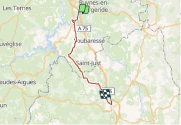
13- Viaduc de Garabit - St Chely d'Apcher

v.hanosset
Gebruiker

Lengte
27 km

Max. hoogte
1101 m

Positief hoogteverschil
620 m
Km-Effort
34 km

Min. hoogte
734 m

Negatief hoogteverschil
391 m
Boucle
Neen
Datum van aanmaak :
2023-01-12 14:15:04.528
Laatste wijziging :
2023-02-24 11:01:40.54
2h05
Moeilijkheid : Moeilijk

Gratisgps-wandelapplicatie
 SityTrail
IGN / Geografische instituten
SityTrail Plus
De wereld gaat voor u open
Over ons
Tocht Wegfiets van 27 km beschikbaar op Auvergne-Rhône-Alpes, Cantal, Val d'Arcomie. Deze tocht wordt voorgesteld door v.hanosset.
Plaatsbepaling
Land:
France
Regio :
Auvergne-Rhône-Alpes
Departement/Provincie :
Cantal
Gemeente :
Val d'Arcomie
Locatie:
Loubaresse
Vertrek:(Dec)
Vertrek:(UTM)
514006 ; 4980121 (31T) N.
Opmerkingen