Tocht Te voet Tanneron -  Tanneron-les mimosas-13-01-23 - Photo

Tanneron-les mimosas-13-01-23

 Christiancordin
Christiancordin

Gebruiker

© OpenStreetMap contributors
Lengte
Lengte
16,1 km
Max. hoogte
Max. hoogte
480 m
Positief hoogteverschil
532 m
Km-Effort
Km-Effort  
23 km
Min. hoogte
Min. hoogte
155 m
Negatief hoogteverschil
532 m
Boucle
Boucle
Ja
Datum van aanmaak :
2023-01-15 17:38:15.027
Laatste wijziging :
2023-01-15 17:47:17.594

(0 Bericht)

Te voet
Te voet
5h16
Moeilijkheid : Medium

Scan deze QR-code om de tocht te openen in de SityTrail-applicatie

Gratisgps-wandelapplicatie

Logo SityTrail SityTrail

IGN / Geografische instituten

SityTrail uit de App Store downloaden SityTrail uit Google Play downloaden

Logo SityTrail SityTrail Plus

De wereld gaat voor u open

SityTrail uit de App Store downloaden SityTrail uit Google Play downloaden SityTrail op Huawei AppGallery downloaden

Over ons

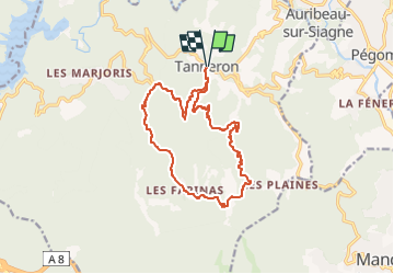
Tocht Te voet van 16,1 km beschikbaar op Provence-Alpes-Côte d'Azur, Var, Tanneron. Deze tocht wordt voorgesteld door Christiancordin.

Beschrijving

Tanneron Pk après la mairie à droite conseillé aux randonneurs-colle d'Embarque-vallon des Serres-vallon de l'Aubarie-les Farinas-les Grailles-Les Margoutons-vallon de Latone-Tanneron.

Hoogteprofiel

Foto's

Plaatsbepaling

Land:
France
Regio :
Provence-Alpes-Côte d'Azur
Departement/Provincie :
Var
Gemeente :
Tanneron
Locatie:
Unknown
Vertrek:(UTM)
328553 ; 4828538 (32T) N.


Sluiten
Mijn abonnementen