


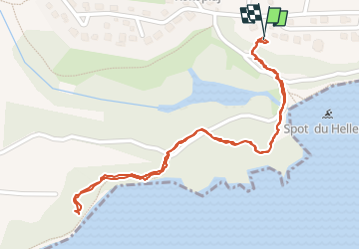
Tipayoune - Bois Jolan

AMOROS
Gebruiker

Lengte
1,9 km

Max. hoogte
14 m

Positief hoogteverschil
25 m
Km-Effort
2,3 km

Min. hoogte
0 m

Negatief hoogteverschil
26 m
Boucle
Ja
Datum van aanmaak :
2023-01-17 19:13:22.0
Laatste wijziging :
2023-01-17 21:01:54.948
47m
Moeilijkheid : Gemakkelijk

Gratisgps-wandelapplicatie
 SityTrail
IGN / Geografische instituten
SityTrail Plus
De wereld gaat voor u open
Over ons
Tocht Stappen van 1,9 km beschikbaar op Guadeloupe, Onbekend, Sainte-Anne. Deze tocht wordt voorgesteld door AMOROS.
Plaatsbepaling
Land:
France
Regio :
Guadeloupe
Departement/Provincie :
Onbekend
Gemeente :
Sainte-Anne
Locatie:
Unknown
Vertrek:(Dec)
Vertrek:(UTM)
677421 ; 1796517 (20Q) N.
Opmerkingen